FASS Staff Profile

DR LUO WEI
ASSISTANT PROFESSOR
DEPARTMENT of GEOGRAPHY
- Appointment:
- ASSISTANT PROFESSOR
- Office:
- AS2-04-32
- Email:
- geowl@nus.edu.sg
- Tel:
- Fax:
- Homepage:
- https://profile.nus.edu.sg/fass/geowl/
- Director GeoSpatialX Lab at NUS (with lastest academic information)
- Assistant Professor Geography Department at National University of Singapore
- Assistant Professor NUS Saw Swee Hock School of Public Health
- Cofounder of GeoHealth Hub
- Secretary General of Modeling Geographical Systems Commission (MGSC) in International Geographical Union (IGU)
Hello, I'm Luo Wei, a GIScientist, Data Visualizer, Network Scientist, and Epidemologist. Before I joined in NUS, I was a Research Associate in Computational Health Informatics Program (CHIP) at Boston Children's Hospital and Harvard Medical School. I received my Master degree from Geography department at University at Buffalo and PhD degree at Penn State University. I have broad training backgrounds in Geography (GIScience), Public Health (Epidemiology), Computer Science (Visual Analytics), and Network Science. I proposed a new research area: geo-social visual analytics, which aims to integrate spatial analysis, social network analysis, and machine learning into visual analytics environments. I have designed and developed a series of geovisual analytics tools and high performance computational models for infectious disease transmission and control (i.e., COVID-19, Dengue, influenza, HIV), international trade, social media, crime analysis, climate change impacts, and water crisis. Based on the geo-social interaction area (complex system), my research at NUS has two major application research focuses: infectious disease transmission and control (i.e., disease transmission networks) and international trade and supply chain (national or firm networks). Please follow my 

 .
.
I always welcome students/visiting scholars who are interested in my research to join in my lab.
Lab Members
Graduate Students


Yang Zihui Liu Zhaoyin Lawrence Chew Zheng Xiong
Urban analysis and planning GIS and public health AI/ML/DL, Maritime GeoSpatial Applications, Front End Web Development for GIS


Wang Haoran Zhou Yuxuan Su Lixian
Spatial data analysis, AI,spatial modeling,Map visualization Urban planning, spatial analytics Geographic Data Mining
GIS, public health and global trade
Visiting Scholar

Urban Spatial Structure, GIS Analysis, GeoAI, Spatial Statistics
Intern


Zhang Shirui He Lingfeng Mohit Chaurasiya
Consumer insights, healthcare analytics, visualization Computational Sociology GIS and ML applications in spatial data analysis

Computational Sociology

Public Policy, Public health, Environmental Economics and Climate Change
(Risk Monitoring and Renewable Energy Practices)
- GIScience
- Geovisualization
- Spatial Programming
- GeoHealth
- Social Network
- Big Spatio-Temporal Data Analytics
- Remote Sensing
NUS
GE5219 Spatial Programming (2021 2022 Spring) Featured Student Group Projects: Youtube Bilibili
GE4214 Remote Sensing of Environment (2021 Spring)
GE5228 Spatial Big Data and Analytics (2021 Fall) Student Group Projects: Youtube Bilibili
GE5225 Thesis Planning and Implementation (2022 Spring)
- Infectious Disease Surveillance, Transmission, and Control (COVID-19, Influenza, HIV, Dengue)
- Geovisual Analytics
- Social Network Analysis
- Machine Learning and AI
- Agent-based Epidemic Modeling
CHAPTERS IN BOOKS
-
- Luo W, Wang YL, Liu X, and Gao S 2019. Cities as Spatial and Social Networks: towards a Spatio-Socio-Semantic Analysis Framework. In: Ye XY and Liu XJ ed. Cities as Spatial and Social Networks. Human Dynamics in Smart Cities. Springer, Cham. [doi]
- Gao S, Chen HZ, Luo W, Hu YJ, and Ye XY 2018. Spatiotemporal-Network Visualization for Exploring Human Activities and Interactions in Physical and Virtual Space. In: Shaw SL and Sui D ed. Human Dynamics Research in the Changing World. [doi]
ARTICLES IN JOURNAL
-
- Hu, T. †, S. Wang †, Luo W†*, M. Zhang, X. Huang, Y. Yan, R. Liu, K. Ly, V. Kacker, B. She & Z. Li (2021) Revealing public opinion towards COVID-19 vaccines with Twitter Data in the United States: a spatiotemporal perspective. Journal of Medical Internet Research [doi].
- Yin, L., Zhang, H., Li, Y., Liu, K., Chen, T., Luo, W., Lai, S., Li, Y., Tang, X., Ning, L. and Feng, S., 2021. A data driven agent-based model that recommends non-pharmaceutical interventions to suppress Coronavirus disease 2019 resurgence in megacities. Journal of the Royal Society Interface, 18(181), p.20210112 [doi].
- Lai SJ, Feng LZ , Leng ZW, Lyu X, Li RY, Yin L, Luo W , Li ZJ, Lan YJ, Yang WZ. Summary and prospect of early warning models and systems for infectious disease outbreaks. Chinese journal of Epidemiology. 2021 Aug 10;42(8):1330-5.[doi]
- Castro, L. A., N. Generous†, Luo W†, A. Pastore y Piontti, K. Martinez, M. F. C. Gomes, D. Osthus, G. Fairchild, A. Ziemann, A. Vespignani, M. Santillana, C. A. Manore & S. Y. Del Valle (2021) Using heterogeneous data to identify signatures of dengue outbreaks at fine spatio-temporal scales across Brazil. PLOS Neglected Tropical Diseases, 15, e0009392. [doi]
-
Luo W, Yuan M. Identifying temporal patterns of multilateral spatial interactions: Using international trades as an example. Transactions in GIS. 2021;00:1– 22. [doi]
- Poirier C, Luo W, Majumder M.S, Liu D, Mandl K, Mooring T, Santillana, M., 2020. The Role of Environmental Factors on Transmission Rates of the COVID-19 Outbreak: An Initial Assessment in Two Spatial Scales. Scientific Reports. [doi]
- Arif Masrur, Manzhu Yu, Luo W, Ashraf Dewan.2020. Prospective time-periodic surveillance and space-time tracking of COVID-19 infections in Bangladesh. International Journal of Environmental Research and Public Health.[doi]
- SJ Lai, N W Ruktanonchai, LC Zhou, O Prosper, Luo W, Jessica R Floyd, Amy Wesolowski, Santillana, M., Chi Zhang, Xiangjun Du, Hongjie Yu, and Andrew J Tatem Effect of non-pharmaceutical interventions for containing the COVID-19 outbreak: an observational and modelling study (2020). Nature. [doi]
- Luo W, Gao P, and Cassels S. A Large-Scale Location-based Social Network to Understanding the Impact of Human Geo-Social Interaction Patterns on Vaccination Strategies in an Urbanized Area. (2018). Computers. Environment and Urban Systems Special Issue: Human Dynamics in the Mobile and Big Data Era: Towards smart and connected communities. 72. [doi]
- Luo W, Katz D, Hamilton D, McKennie J, Jenness S, Goodreau S, Stekler J, Rosenberg E, Sullivan P., and Cassels S. (2018) Development of an Agent-based Model to Investigate the Impact of HIV Self-testing Programs for Men Who Have Sex with Men in Atlanta and Seattle. JMIR Public Health Surveill. 2018;4(2):e58. [doi]
- Luo W, Steptoe M, Chang Z, Link R, Clarke L, and Maciejewski R. 2017 The Impact of Spatial Scales on the Inter-Comparison of Climate Scenarios. IEEE Computer Graphics & Applications Special Issue: Geographic Data Science. 37(5). [doi]
- Luo W 2016 Visual Analytics of Geo-Social Interaction Patterns for Epidemic Control. International Journal of Health Geographics. 15(28). [doi]
- Zhang YF, Luo W, Mack AE, and Maciejewski R. 2016 Visualizing the Impact of Geographical Variations on Multivariate Clustering. Computer Graphics Forum 35(3). [doi]
- Peuquet DJ, Robinson AC, Stehle S, Hardisty F, and Luo W. 2015 A Method for Discovery and Analysis of Temporal Patterns in Complex Event Data. International Journal of Geographical Information Science 29(9). [doi]
- Luo W, Yin PF, Di Q, Hardisty F, and MacEachren AM. 2014 A Geovisual Analytic Approach to Understanding Spatial-Social Relationships in the International Trade Network. PLoS ONE 9(2): e88666. [doi]
- Luo W, MacEachren AM. 2014 Geo-Social Visual Analytics. Journal of Spatial Information Science. 8. [doi]
- Roth RE, Ross KS, Finch BG, Luo W, and MacEachren AM. 2013. Spatiotemporal crime analysis in U.S. law enforcement agencies: Current practices and unmet needs. Government Information Quarterly. [doi]
- Blanford JI, Kumar S, Luo W, and MacEachren AM. 2012. It's a long, long walk: accessibility to hospitals, maternity and integrated health centers in Niger. International Journal of Health Geographics. 11(24). [doi]
- Chen WL, Wu XS, Luo W, Yang XJ, and Zhao R. 2007. Risk Analysis of Land Use of large historic sites in the suburb—A case Study of Chang’an City of Han Dynasty. Resources Science. 29(3): 198-205. [link]
CONFERENCE PAPERS
-
- Steptoe M, Krueger R, Zhang YF., Liang X, Garcia R, Kadambi S, Luo W, Ertl T, and Maciejewski R. 2015 VAST Challenge 2015: Grand Challenge - Team VADER/VIS Award for Outstanding Comprehensive Submission. In: 2015 IEEE Conference on Visual Analytics Science and Technology (VAST). Chicago, Illinois: Oct 25-30. [doi]
- Luo W, Chang Z, Kong LL, Link R, Hejazi M, Clarke L, and Maciejewski R. 2015 Web-Based Visualization of the Global Change Assessment Model. In: Proceedings of Visualization in Environmental Sciences (EnvirVis 2015), EuroVis 2015. Cagliari, Italy: May 25-26. [doi]
- Lukasczyk J, Liang X, Luo W, Ragan E, Middel A, Bliss N, White D, Hagen H, and Maciejewski R. 2015 A Collaborative Web-Based Environmental Data Visualization and Analysis Framework. In: Proceedings of Visualization in Environmental Sciences (EnvirVis 2015), EuroVis 2015. Cagliari, Italy: May 25-26. [doi]
- Lei T, Liang X, Mascaro G, Luo W, White D, Westerhoff P, and Maciejewski R. 2015 An Interactive Web-Based Geovisual Analytics Tool to Explore Water Scarcity in Niger River Basin. In: Proceedings of Visualization in Environmental Sciences (EnvirVis 2015), EuroVis 2015. Cagliari, Italy: May 25-26. [doi]
- Luo W, MacEachren AM, Yin PF, and Hardisty F. 2011. Spatial-Social Network Visualization for Exploratory Data Analysis. In: Proceedings of 3rd ACM SIGSPATIAL International Workshop on Location-Based Social Networks (LBSN 2011), 19th ACM SIGSPATIAL International Conference on Advances in Geographic Information Systems (ACM SIGSPATIAL GIS 2011). Illinois, Chicago: November 1-4. [doi]
- Savelyev, A, Janowicz, K, Thatcher, J, Xu, S, Mülligann, C, and Luo, W. 2011. Volunteered Geographic Services: Developing a Linked Data Driven Location-based Service. In: SIGSPATIAL International Workshop on Spatial Semantics and Ontologies in conjunction with the ACM SIGSPATIAL International Conference on Advances in Geographic Information Systems (ACM SIGSPATIAL GIS 2011). Illinois, Chicago: November 1-4. [doi]
- Thatcher, J, Mülligann, C, Luo, W, Xu, S, Guidero, E, and Janowicz, K. 2011. Hidden ontologies - how mobile computing affects the conceptualization of geographic space. In: Proceedings of Workshop on Cognitive Engineering for Mobile, Conference on Spatial Information Theory: COSIT'11. Belfast, Maine: September 12-16. [link]
- Roth RE, Ross KS, Finch BG, Luo W, and MacEachren AM. 2010. A user-centered approach for designing and developing spatiotemporal crime analysis tools. In: Proceedings of GIScience 2010. Zurich, Switzerland: September 15. [link]
UNPUBLISHED REPORTS
-
- Luo, W, Majumder, M.S., Liu, D., Poirier, C., Mandl, K.D., Lipsitch, M. and Santillana, M., 2020. The role of absolute humidity on transmission rates of the COVID-19 outbreak. medRxiv. [doi]
- Savelyev A, MacEachren AM, Pezanowski S, Karimzadeh M, Luo W, Jonathan N, and Robinson, A.C. 2014: Report on New Methods for Representing and Interacting with Qualitative Geographic Information, Stage 2: Task Group 4: Message-focused use case. Report on New Methods for Representing and Interacting with Qualitative Geographic Information, Contract #: W912HZ-12-P-0334, University Park, PA: GeoVISTA Center, Department of Geography, The Pennsylvania State University. [link]
- MacEachren AM, Savelyev A, Luo W, Pezanowski S, Karimzadeh M, Robinson AC and Mitra P. 2014: Report on New Methods for Representing and Interacting with Qualitative Geographic Information, Stage 2: Task Group 3: Social-focused use case. Report on New Methods for Representing and Interacting with Qualitative Geographic Information, Contract #: W912HZ-12-P-0334, University Park, PA: GeoVISTA Center, Department of Geography, The Pennsylvania State University. [link]
- MacEachren AM, Karimzadeh M, Banerjee S, Luo W, Savelyev A, Pezanowski S, Robinson AC, and Mitra P. 2013: Report on New Methods for Representing and Interacting with Qualitative Geographic Information, Stage 2: Task Group 2: Tweeter-focused use case. Report on New Methods for Representing and Interacting with Qualitative Geographic Information, Contract #: W912HZ-12-P-0334, University Park, PA: GeoVISTA Center, Department of Geography, The Pennsylvania State University. [link]
- The Geospatial World 50 Rising Stars 2023
- Highlighted chapter at AAG Received for “Cities as spatial and social networks: towards a spatio-socio-semantic analysis framework. In Cities as Spatial and Social Networks” Nominated along with Luo, W., Wang, Y., Liu, X., & Gao, S
- Waldo-Tobler Young Researcher Awards from Austrian Academy of Sciences’ Commission of GIScience Received for the title “Geo-Social Visual Analytics”.
- Award for Outstanding Comprehensive Submission from VADER/VIS-Grand Challenge
- Best Presentation from National Geospatial‐Intelligence Agency (NGA) fall symposium.
- E. Willard Miller Award in Geography, Penn State University, PhD Level: 1st Place. Received for the title “Geo-Social Visual Analytics”.
- GIScience Best Paper Award: Finalist, Extended Abstract Category.
Global Change Assessment Model(GCAM) Visual Analytics
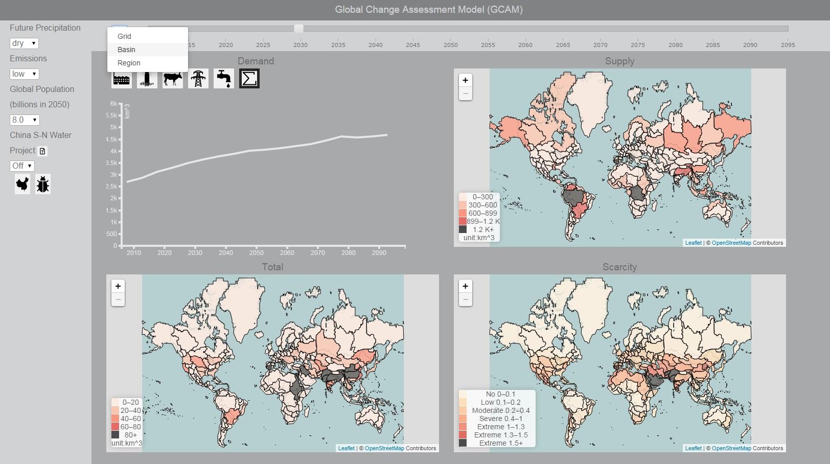
This is a web-based geovisual analytics approach for enabling the exploration of climate scenarios from GCAM. It consists of geographical, temporal, and multidimensional spaces, which allows users to explore water scarcity in terms of geographical variations, temporal change, and scenario comparison with different future climate policies. It further implements clustering approach into a visual analytics environment to facilitate model uncertainty exploration among different climate scenarios.
- Luo W, Steptoe M, Chang Z, Link R, Clarke L, and Maciejewski R. 2017 The Impact of Spatial Scales on the Inter-Comparison of Climate Scenarios. IEEE Computer Graphics & Applications Special Issue: Geographic Data Science. 37(5). [doi]
- Luo W, Chang Z, Kong LL, Link R, Hejazi M, Clarke L, and Maciejewski R. 2015 Web-Based Visualization of the Global Change Assessment Model.In: Proceedings of Visualization in Environmental Sciences (EnvirVis 2015), EuroVis 2015. Cagliari, Italy: May 25-26. [doi]
GeoSocialApp
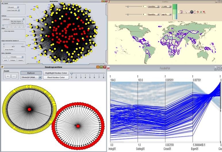
The GeoSocialApp is a visualization tool that supports the exploration of spatial-social networks among network, geographical, and attribute spaces. Using mixed methods - computational and visual, it enables discovery of complex patterns in large spatial-social network datasets in an effective and efficient way.
- Luo W, Yuan M. 2020. Identifying temporal patterns of multilateral spatial interactions: using international trade as an example. Transactions in GIS. [doi].
- Luo W, Yin PF, Di Q, Hardisty F, and MacEachren AM. 2014 A Geovisual Analytic Approach to Understanding Spatial-Social Relationships in the International Trade Network. PLoS ONE 9(2): e88666. [doi]
- Luo W, MacEachren AM. 2014 Geo-Social Visual Analytics. Journal of Spatial Information Science. 8. [doi]
- Luo W, MacEachren AM, Yin PF, and Hardisty F. 2011. Spatial-Social Network Visualization for Exploratory Data Analysis. In: Proceedings of 3rd ACM SIGSPATIAL International Workshop on Location-Based Social Networks (LBSN 2011), 19th ACM SIGSPATIAL International Conference on Advances in Geographic Information Systems (ACM SIGSPATIAL GIS 2011). Illinois, Chicago: November 1-4. [doi]
GeoSocialEpidemicViz
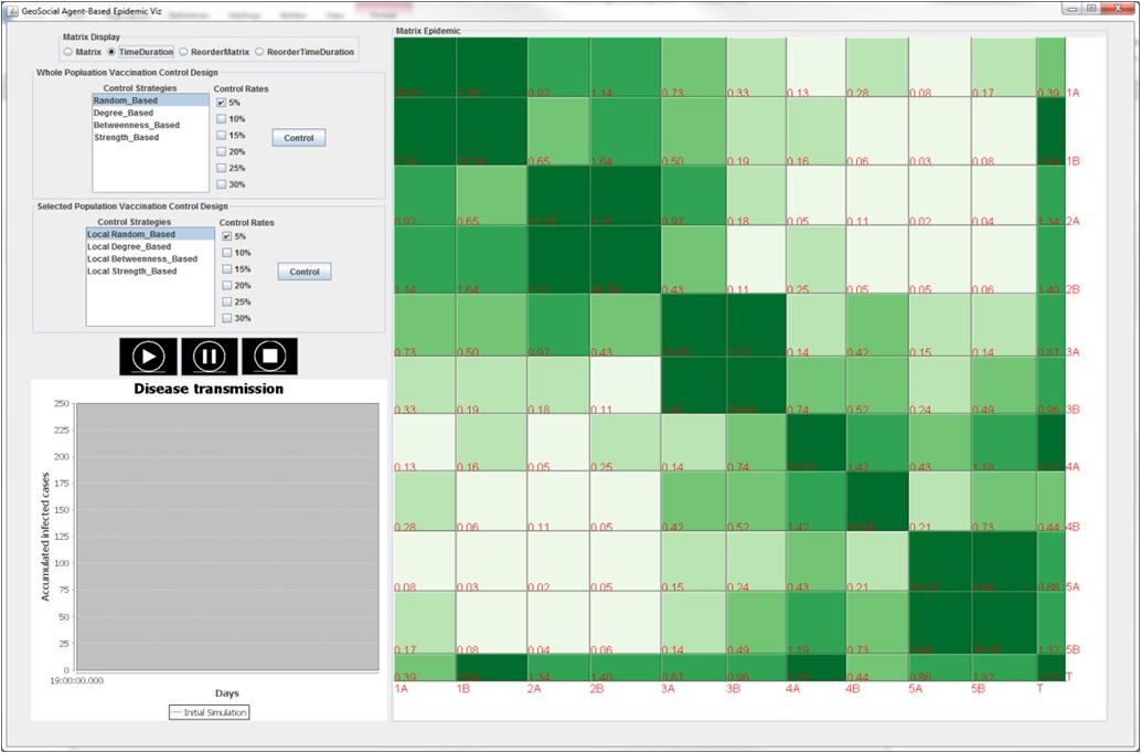
GeoSocialEpidemic allows researchers understand individual-level epidemic transmission and control scenario design. It allows the exploration of human interaction patterns and design control scenarios based on those local human interaction patterns.
- Luo W 2016 Visual Analytics of Geo-Social Interaction Patterns for Epidemic Control. International Journal of Health Geographics. 15(28). [doi]
Spatiotemporal Visual Analytics
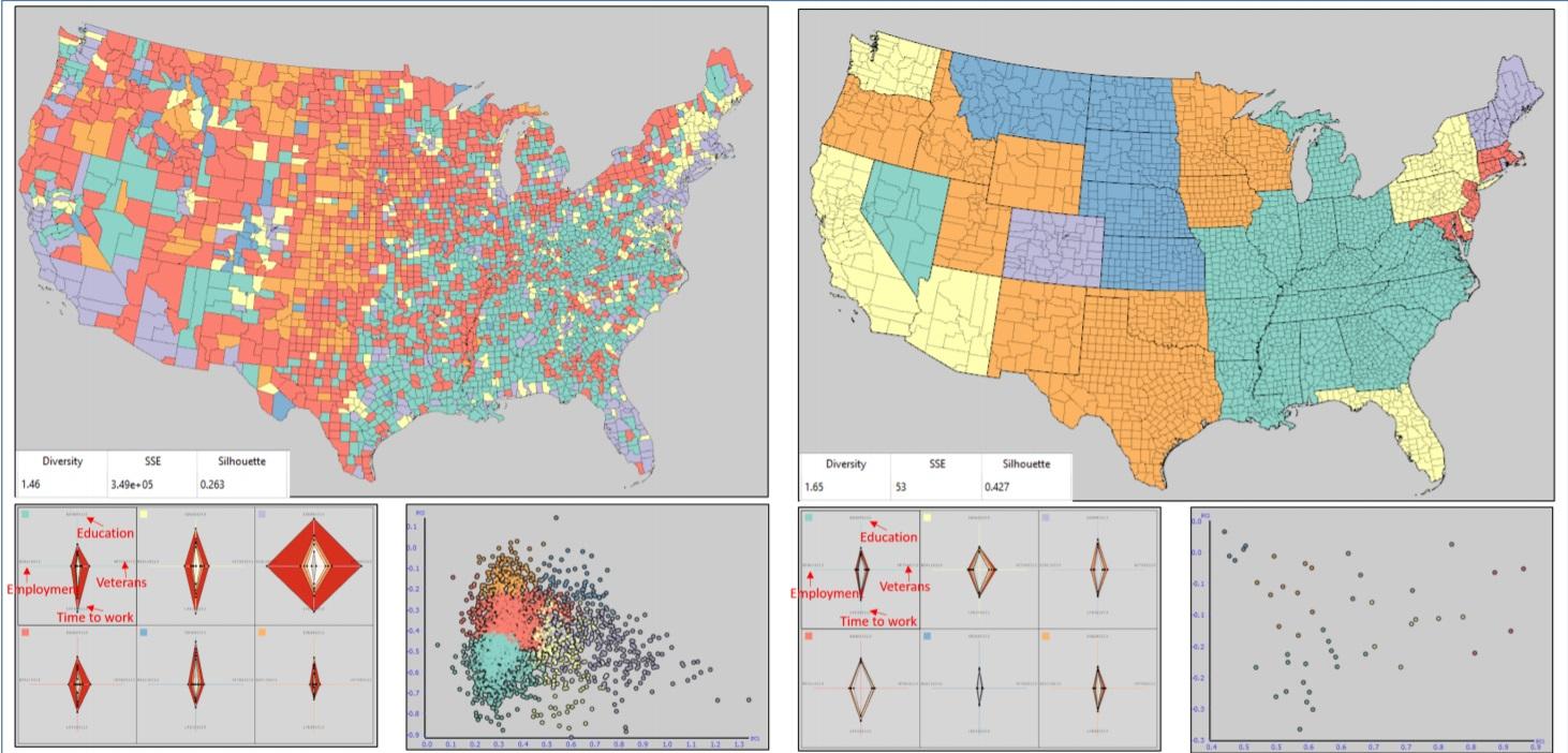
We develop a visual analytics framework for exploring and comparing the impact of geographical variations for multivariate clustering. Our framework employs a variety of graphical configurations and summary statistics to explore the spatial extents of clustering. It also allows users to discover patterns that can be concealed by traditional global clustering via several interactive visualization techniques including a novel drag & drop clustering difference view.
- Zhang YF, Luo W, Mack AE, and Maciejewski R. 2016 Visualizing the Impact of Geographical Variations on Multivariate Clustering. Computer Graphics Forum 35(3). [doi]
Geovisual Analytics for Water Scarcity in Niger River Basin
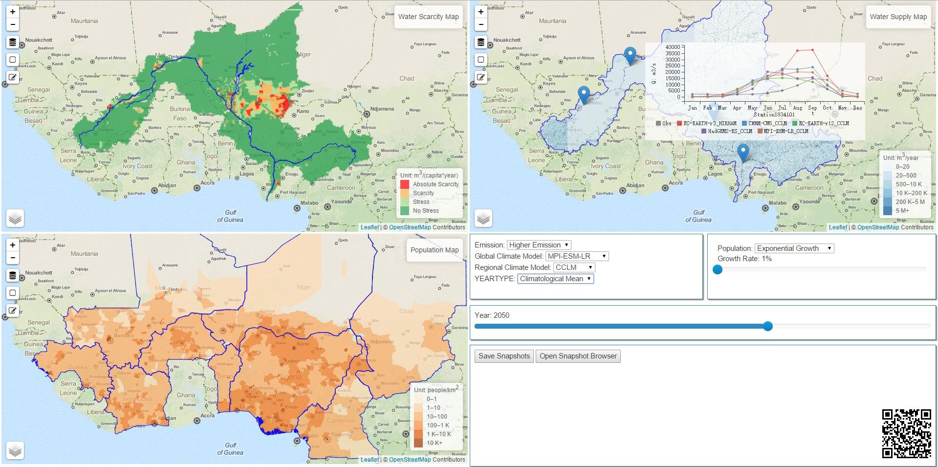 This is a web-based geovisual analytics approach to explore water supply, demand, and scarcity in the Niger River Basin area under various scenarios. This tool can compare and analyze the uncertainty associated with these scenarios. This tool can also provide a collaborative environment.
- Lukasczyk J, Liang X, Luo W, Ragan E, Middel A, Bliss N, White D, Hagen H, and Maciejewski R. 2015 A Collaborative Web-Based Environmental Data Visualization and Analysis Framework. In: Proceedings of Visualization in Environmental Sciences (EnvirVis 2015), EuroVis 2015. Cagliari, Italy: May 25-26. [doi]
- Lei T, Liang X, Mascaro G, Luo W, White D, Westerhoff P, and Maciejewski R. 2015 An Interactive Web-Based Geovisual Analytics Tool to Explore Water Scarcity in Niger River Basin. In: Proceedings of Visualization in Environmental Sciences (EnvirVis 2015), EuroVis 2015. Cagliari, Italy: May 25-26. [doi]
VAST Challenge 2015: Grand Challenge
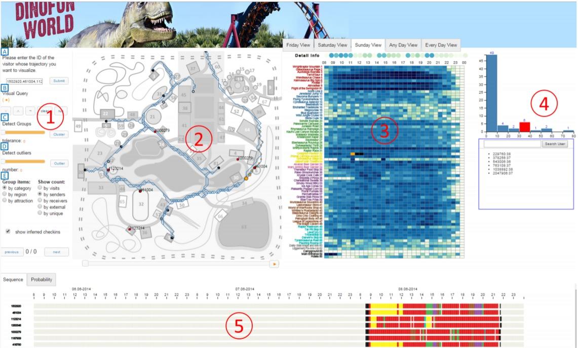
The VAST 2015 Grand Challenge focused on a fictional park called DinoFun World where visitors are provided with a handheld device for communicating with park patrons and registering their visits to rides. In order to facilitate this data exploration, we have created a webdeployable system that combines data wrangling, trajectory analysis, network analysis, and interactive visualizations for discovering movement and communication patterns of users and their networks. We earned the Award for Outstanding Comprehensive Submission. Here is the video link.
- Steptoe M, Krueger R, Zhang YF., Liang X, Garcia R, Kadambi S, Luo W, Ertl T, and Maciejewski R. 2015 VAST Challenge 2015: Grand Challenge - Team VADER/VIS Award for Outstanding Comprehensive Submission. In: 2015 IEEE Conference on Visual Analytics Science and Technology (VAST). Chicago, Illinois: Oct 25-30. [doi]
Senseplace2
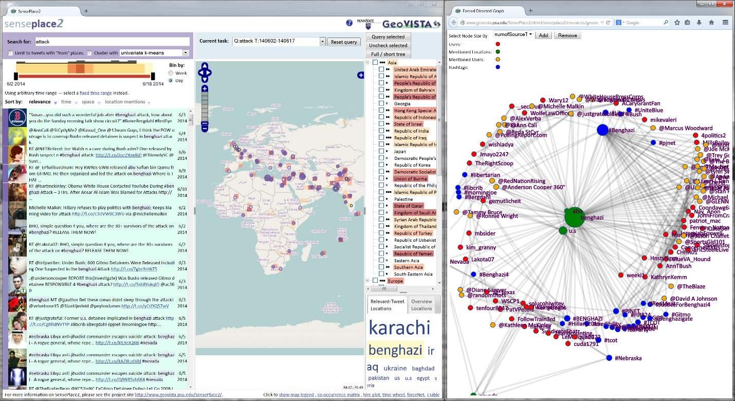
This web-based tool provides a visual interface and display methods for query and exploration of large repositories of microblog data. The emphasis is on revealing the where, when, what, and who components of microblog data to support situational awareness in natural disasters and other emergency events. Here is the video link.
- Savelyev A, MacEachren AM, Pezanowski S, Karimzadeh M, Luo W, Jonathan N, and Robinson, A.C. 2014: Report on New Methods for Representing and Interacting with Qualitative Geographic Information, Stage 2: Task Group 4: Message-focused use case. Report on New Methods for Representing and Interacting with Qualitative Geographic Information, Contract #: W912HZ-12-P-0334, University Park, PA: GeoVISTA Center, Department of Geography, The Pennsylvania State University. [link]
- MacEachren AM, Savelyev A, Luo W, Pezanowski S, Karimzadeh M, Robinson AC and Mitra P. 2014: Report on New Methods for Representing and Interacting with Qualitative Geographic Information, Stage 2: Task Group 3: Social-focused use case. Report on New Methods for Representing and Interacting with Qualitative Geographic Information, Contract #: W912HZ-12-P-0334, University Park, PA: GeoVISTA Center, Department of Geography, The Pennsylvania State University. [link]
- MacEachren AM, Karimzadeh M, Banerjee S, Luo W, Savelyev A, Pezanowski S, Robinson AC, and Mitra P. 2013: Report on New Methods for Representing and Interacting with Qualitative Geographic Information, Stage 2: Task Group 2: Tweeter-focused use case. Report on New Methods for Representing and Interacting with Qualitative Geographic Information, Contract #: W912HZ-12-P-0334, University Park, PA: GeoVISTA Center, Department of Geography, The Pennsylvania State University. [link]
STempo
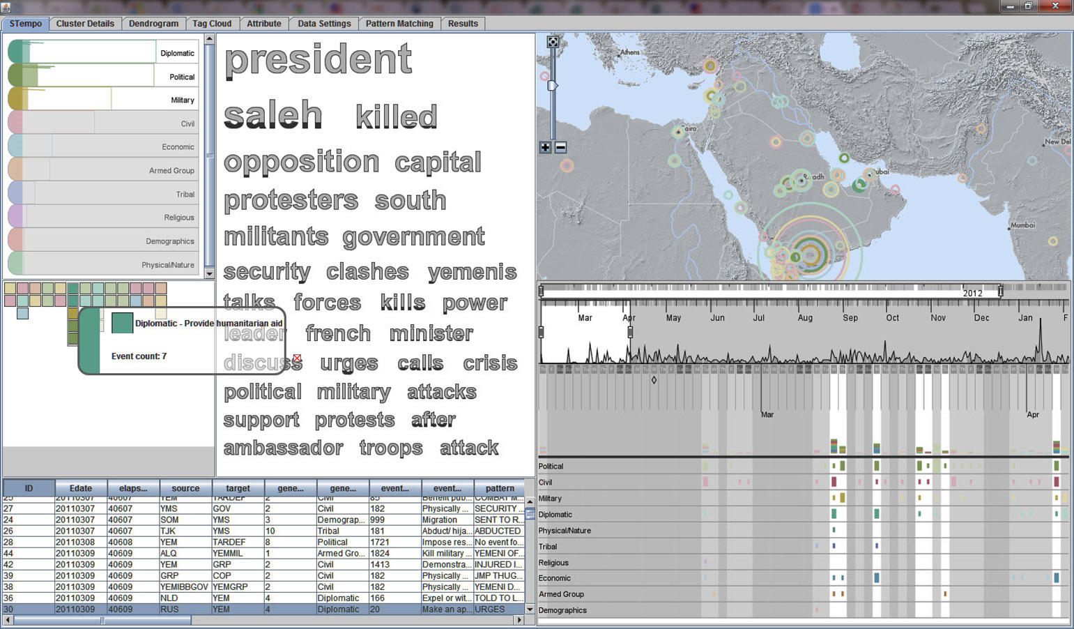
The STempo visualization environment supports the discovery and visual exploration of pattern results from space-time event data. STempo provides a wide range of coordinated view displays with which users can investiage space, time, and attribute data to uncover patterns and phenomena. Here is the video link.
- Peuquet DJ, Robinson AC, Stehle S, Hardisty F, and Luo W. 2015 A Method for Discovery and Analysis of Temporal Patterns in Complex Event Data. International Journal of Geographical Information Science 29(9). [doi]
CrimeViz
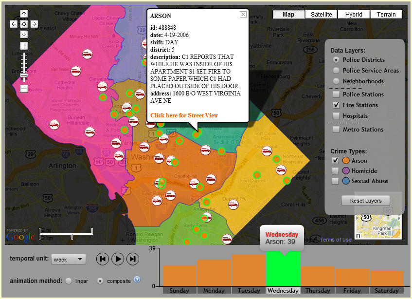
CrimeViz is an extensible web-based map application that supports exploration of and sensemaking about crimninal activity in space and time. Here is the video link.
- Roth RE, Ross KS, Finch BG, Luo W, and MacEachren AM. 2013. Spatiotemporal crime analysis in U.S. law enforcement agencies: Current practices and unmet needs. Government Information Quarterly. [doi]
- Roth RE, Ross KS, Finch BG, Luo W, and MacEachren AM. 2010. A user-centered approach for designing and developing spatiotemporal crime analysis tools. In: Proceedings of GIScience 2010. Zurich, Switzerland: September 15. [link]
PSUMobile
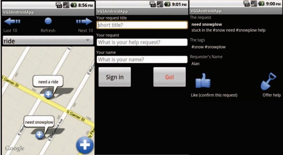
PSUMobile serves volunteered geographic service (VGS) on android platform. The project involves GoogleMaps API (for Android), server-client communication and linked database.
- Savelyev, A, Janowicz, K, Thatcher, J, Xu, S, Mülligann, C, and Luo, W. 2011. Volunteered Geographic Services: Developing a Linked Data Driven Location-based Service. In: SIGSPATIAL International Workshop on Spatial Semantics and Ontologies in conjunction with the ACM SIGSPATIAL International Conference on Advances in Geographic Information Systems (ACM SIGSPATIAL GIS 2011). Illinois, Chicago: November 1-4. [doi]
- Thatcher, J, Mülligann, C, Luo, W, Xu, S, Guidero, E, and Janowicz, K. 2011. Hidden ontologies - how mobile computing affects the conceptualization of geographic space. In: Proceedings of Workshop on Cognitive Engineering for Mobile, Conference on Spatial Information Theory: COSIT'11. Belfast, Maine: September 12-16. [link]
COVID-19
- Hu, T. †, S. Wang †, Luo W†*, M. Zhang, X. Huang, Y. Yan, R. Liu, K. Ly, V. Kacker, B. She & Z. Li (2021) Revealing public opinion towards COVID-19 vaccines with Twitter Data in the United States: a spatiotemporal perspective. Journal of Medical Internet Research [doi].
- Luo, W, Majumder, M.S., Liu, D., Poirier, C., Mandl, K.D., Lipsitch, M. and Santillana, M., 2020. The role of absolute humidity on transmission rates of the COVID-19 outbreak. medRxiv. [doi]
- Poirier C, Luo W, Majumder M.S, Liu D, Mandl K, Mooring T, Santillana, M., 2020. The Role of Environmental Factors on Transmission Rates of the COVID-19 Outbreak: An Initial Assessment in Two Spatial Scales. Scientific Reports. [doi]
- Arif Masrur, Manzhu Yu, Luo W, Ashraf Dewan.2020. Prospective time-periodic surveillance and space-time tracking of COVID-19 infections in Bangladesh. International Journal of Environmental Research and Public Health.[doi]
- SJ Lai, N W Ruktanonchai, LC Zhou, O Prosper, Luo W, Jessica R Floyd, Amy Wesolowski, Santillana, M., Chi Zhang, Xiangjun Du, Hongjie Yu, and Andrew J Tatem Effect of non-pharmaceutical interventions for containing the COVID-19 outbreak: an observational and modelling study (2020). Nature. [doi]
Dengue
Castro, L. A., N. Generous†, Luo W†, A. Pastore y Piontti, K. Martinez, M. F. C. Gomes, D. Osthus, G. Fairchild, A. Ziemann, A. Vespignani, M. Santillana, C. A. Manore & S. Y. Del Valle (2021) Using heterogeneous data to identify signatures of dengue outbreaks at fine spatio-temporal scales across Brazil. PLOS Neglected Tropical Diseases, 15, e0009392. [doi]
Influenza
This research examined the impact of geo-social interaction patterns on effective vaccination strategies in the urbanized area of Portland, Oregon. To achieve this goal, we built a large-scale two-layer locationbased social network model including an innovative location-based network to design vaccination strategies and an individual-based spatially explicit disease model to evaluate the efficacy of the above vaccination strategies. We implemented the network model in parallel algorithms to take advantage of a high performance platform of CPU to tackle the challenge of extremely intensive computation with millions of nodes and edges.
- Luo W, Gao P, and Cassels S. A Large-Scale Location-based Social Network to Understanding the Impact of Human Geo-Social Interaction Patterns on Vaccination Strategies in an Urbanized Area. (2018). Computers. Environment and Urban Systems Special Issue: Human Dynamics in the Mobile and Big Data Era: Towards smart and connected communities. 72. [doi]
HIV
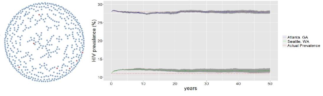
I develop the first agent-based epidemic modeling to understand how HIV self-test impacts HIV incidence among men who have sex with men MSM in different urban settings. All of my codes are open source under a big project called Statnet for the analysis, simulation and visualization of network data in HPC environment: https://github.com/statnet.
- Luo W, Katz D, Hamilton D, McKennie J, Jenness S, Goodreau S, Stekler J, Rosenberg E, Sullivan P., and Cassels S. (2018) Development of an Agent-based Model to Investigate the Impact of HIV Self-testing Programs for Men Who Have Sex with Men in Atlanta and Seattle. JMIR Public Health Surveill. 2018;4(2):e58. [doi]
Spatial Accessibility
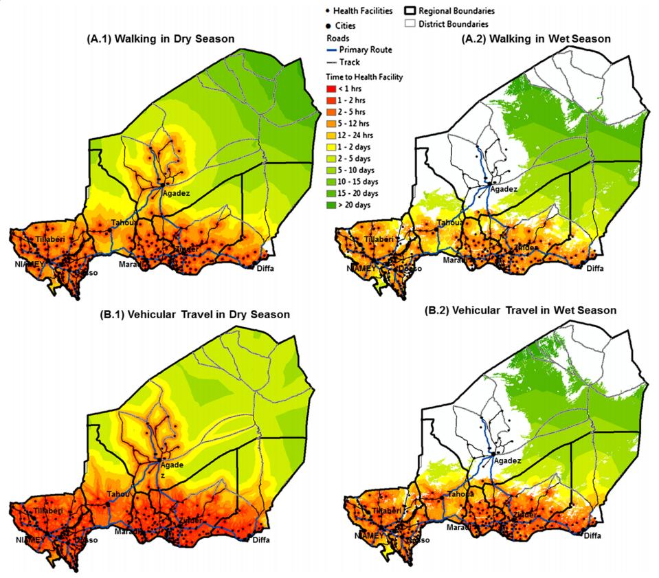
This project analyzes the physical access of populations to health facilities within Niger with an emphasis on the effect of seasonal conditions and the implications of these conditions in terms of availability of adequate health services, provision of drugs and vaccinations.
- Blanford JI, Kumar S, Luo W, and MacEachren AM. 2012. It's a long, long walk: accessibility to hospitals, maternity and integrated health centers in Niger. International Journal of Health Geographics. 11(24). [doi]
1. PhD students: Our lab focuses on spatio-temporal analysis, network analysis, geovisual analytics, GeoAI, epidemiology, public health, and international trade/supply chain, feel free to send me an email with your CV. We always welcome self-motivated students like you to apply for our program. We provide Reseaerch Scholarship and other merit-based scholarhips (here). The graduate student applications will be evaluated by the graduate committee. Here is the NUS Geography PhD admission procedure here.
2. Visiting students: Our lab always welcomes visiting students from other institutions. Please check our research and send me a CV to introduce your research and potential collaboration. Thanks.
Last Modified: 2023-08-03 Total Visits: 14834